


Noting that Antarctic sea ice may show high sensitivity to any anthropogenic-induced increase in temperature, Watkins and Simmonds (2000) analyzed temporal trends in different measures of the sea ice that surrounds Antarctica, using Special Sensor Microwave Imager data obtained from the Defense Meteorological Satellite Program for the nine-year period December 1987-December 1996, in search of the suspected signal. But contrary to what one would expect on the basis of climate model simulations, and especially in light of what climate alarmists of the day described as the unprecedented warming of the past quarter-century, the two scientists observed statistically significant increases in both sea ice area and extent; and when they combined their results with those of the preceding nine-year period (1978-1987), both parameters continued to show increases over that expanded time period. In addition, they found that the 1990s also experienced increases in the length of the sea-ice season.
In a contemporary assessment of Antarctic sea ice behavior, Yuan and Martinson (2000) also utilized Special Sensor Microwave Imager data; but they additionally analyzed brightness temperatures obtained by the Nimbus-7 Scanning Multichannel Microwave Radiometer. And this work revealed that the mean trend in the latitudinal location of the Antarctic sea ice edge over the prior 18 years was an equatorward extension of 0.011 degree of latitude per year, in harmony with the findings of Comiso (2000), who analyzed Antarctic temperature data obtained from 21 surface stations, as well as from infrared satellites operating from 1979 to 1998, and who thereby discovered a 20-year cooling trend of 0.042°C per year in the satellite data and 0.008°C per year in the station data.
The fact that Antarctic sea ice had indeed increased in area, extent and season length since at least 1978 was also supported by several subsequent studies. The very next year, for example, Hanna (2001) published an updated analysis of Antarctic sea ice cover -- also based on Special Sensor Microwave Imager data, but for the extended period of October 1987-September 1999 -- finding "an ongoing slight but significant hemispheric increase of 3.7 (±0.3)% in extent and 6.6 (±1.5)% in area." And one year later, Parkinson (2002) utilized satellite passive-microwave data to calculate and map the length of the sea-ice season throughout the Southern Ocean for each year of the period 1979-1999, finding that although there were opposing regional trends, a "much larger area of the Southern Ocean experienced an overall lengthening of the sea-ice season ... than experienced a shortening."
Concurrently, Zwally et al. (2002) utilized passive-microwave satellite data to study Antarctic sea ice trends. Over the 20-year period 1979-1998, they report that the sea ice extent of the entire Southern Ocean increased by 11,181 ± 4,190 square km per year, or by 0.98 ± 0.37 percent per decade, while sea ice area increased by nearly the same amount: 10,860 ± 3,720 square km per year, or by 1.26 ± 0.43 percent per decade. And in contradiction of the climate-alarmist claim that various aspects of earth's climate should exhibit greater variability when it is warmer than when it is colder, they observed that the variability of monthly sea ice extent declined from 4.0% over the first ten years of the record to 2.7% over the last ten years (which were supposedly the warmest of the prior millennium, according to the world's climate alarmists).
One year later, Vyas et al. (2003) analyzed data from the multi-channel scanning microwave radiometer carried aboard India's OCEANSAT-1 satellite for the period June 1999-May 2001, which they combined with data for the period 1978-1987 that had been derived from space-based passive microwave radiometers carried aboard earlier Nimbus-5, Nimbus-7 and DMSP satellites, in order to study secular trends in sea ice extent about Antarctica over the period 1978-2001. This work revealed that the mean rate of change of sea ice extent for the entire Antarctic region over this period was an increase of 0.043 M km2 per year. In addition, the six researchers concluded that "the increasing trend in the sea ice extent over the Antarctic region may be slowly accelerating in time, particularly over the last decade," which finding they described as "paradoxical in the global warming scenario resulting from increasing greenhouse gases in the atmosphere."
In a somewhat similar study, Cavalieri et al. (2003) extended prior satellite-derived Antarctic sea ice records several years by bridging the gap between Nimbus 7 and earlier Nimbus 5 satellite data sets with National Ice Center digital sea ice data, finding that sea ice extent about Antarctica rose at a mean rate of 0.10 ± 0.05 x 10⁶ km2 per decade between 1977 and 2002. Likewise, Liu et al. (2004) employed sea ice concentration data retrieved from the Scanning Multichannel Microwave Radiometer on the Nimbus 7 satellite, plus the Special Sensor Microwave Imager on several defense meteorological satellites, to develop a quality-controlled history of Antarctic sea ice variability over the period 1979-2002 (which included different states of the Antarctic Oscillation and several ENSO events), after which they evaluated total sea ice extent and area trends by means of linear least-squares regression. This work revealed, in their words, that "overall, the total Antarctic sea ice extent has shown an increasing trend (~4,801 km2/yr)," and that "the total Antarctic sea ice area has increased significantly by ~13,295 km2/yr, exceeding the 95% confidence level."
Shortly thereafter, Parkinson (2004) reviewed the history of satellite observations of sea ice extent in the Southern Ocean about Antarctica, concentrating on data obtained from the Scanning Multichannel Microwave Radiometer aboard the Nimbus 7 satellite and subsequent satellite-based Special Sensor Microwave Imagers, because these platforms provided, in her words, "the best long-term record of changes in the full Southern Ocean ice cover."
The resulting plot of 12-month running-means of Southern Ocean sea ice extent, which extended from November 1978 through December 2002, revealed significant multi-year variability in the data, which began at the top of a peak and ended at the bottom of a trough. But in spite of the high beginning point and low end point of the data, which would mitigate against a long-term upward trend, the data exhibited just such a feature, the least-squares-fit slope of which revealed a 12,380 ± 1,730 km2 upward trend in sea ice extent per year.
In considering this result, it is interesting to note that over the period of time that climate alarmists claim has experienced the most extreme global warming of the past millennium or more, and in spite of the fact they have historically claimed such warming should be most evident in earth's polar regions, and that it should lead to a decrease in polar sea ice extent, just the opposite had occurred to this point in time in the Southern Ocean that surrounds Antarctica. But what is doubly damning to their dogma is the fact that the Southern Ocean's sea ice extent is extremely sensitive to warming, decreasing from a 24-year-average maximum monthly value of 18.23 x 10⁶ km2 in September to a similarly-calculated minimum monthly value of 2.98 x 10⁶ km2 in February. This decrease represents the disappearance of nearly 84% of each year's maximum sea ice cover; and, therefore, it can be appreciated that given just a little extra seasonal warmth, it would disappear altogether each February. But it hasn't. In fact, it continues to slowly, but ever so surely, grow in the mean.
Focusing on the spring-summer period of November/December/January (1981-2000) some four years later, Laine (2008) determined trends in Antarctic ice-sheet and sea-ice surface albedo and temperature, as well as sea-ice concentration and extent, based on Advanced Very High Resolution Polar Pathfinder data in the case of ice-sheet surface albedo and temperature, and the Scanning Multichannel Microwave Radiometer and Special Sensor Microwave Imagers in the case of sea-ice concentration and extent. These analyses were carried out for the continent as a whole, as well as for five longitudinal sectors emanating from the South Pole: 20°E-90°E, 90°E-160°E, 160°E-130°W, 130°W-60°W, and 60°W-20°E. And this work revealed, in Laine's words, that "all the regions show negative spring-summer surface temperature trends for the study period." In addition, the Finnish researcher found that "sea ice concentration shows slight increasing trends in most sectors, where the sea ice extent trends seem to be near zero." Laine also found that "the Antarctic region as a whole and all the sectors separately show slightly positive spring-summer albedo trends." Consequently, over the last two decades of the 20th century, Antarctica successfully bucked the world's supposedly unprecedented global warming trend by (1) cooling a bit, (2) acquiring slightly more sea ice, and (3) becoming a tad more reflective of incoming solar radiation.
Several other studies of the subject were also conducted in 2008. Noting that earth's polar regions "are expected to provide early signals of a climate change primarily because of the 'ice-albedo feedback' which is associated with changes in absorption of solar energy due to changes in the area covered by the highly reflective sea ice," for example, Comiso and Nishio (2008) set about to provide updated and improved estimates of trends in Antarctic sea ice cover for the period extending from November 1978 to December 2006, based on data obtained from the Advanced Microwave Scanning Radiometer, the Special Scanning Microwave Imager and the Scanning Multichannel Microwave Radiometer. And in doing so, they found that the 28-year trends in Antarctic sea ice extent and area were +0.9 ± 0.2 and +1.7 ± 0.3% per decade, which is definitely not a "signal" of global warming.
In another study employing satellite-borne passive microwave radiometer data that extended the analyses of the sea ice time series reported by Zwally et al. (2002) from 20 years (1979-1998) to 28 years (1979-2006), Cavalieri and Parkinson (2008) found that "the total Antarctic sea ice extent trend increased slightly, from 0.96 ± 0.61% per decade to 1.0 ± 0.4% per decade, from the 20- to 28-year period." The Antarctic sea ice area trend, however, remained constant at 1.2 ± 0.7% per decade. Its variability, however, like that of sea ice extent, declined (from ± 0.7% to ± 0.5% per decade), so that both sets of results indicated a "tightening up" of the two relationships. And why were these things so? The two researchers state that "what is driving the observed changes remains unanswered, and the physical mechanisms explaining these changes remain to be determined."
One year later, Turner et al. (2009) reviewed the history of Antarctic sea ice extent derived from satellite observations, after which they attempted to derive an explanation for the empirical data being what they were, based on contrary climate model simulations. Citing the work of Zwalley et al. (2002), they first noted that over the period 1979-1998, sea ice extent surrounding Antarctica increased at a mean rate of 0.98% per decade, and that Comiso and Nishio (2008) derived a value of 0.9% per decade for the period 1978-2006. This sea ice extent increase, according to their modeling work, was largely driven by an autumn increase in the Ross Sea sector that they suggest "is primarily a result of stronger cyclonic atmospheric flow over the Amundsen Sea." And they say that "the trend towards stronger cyclonic circulation is mainly a result of stratospheric ozone depletion, which has strengthened autumn wind speeds around the continent, deepening the Amundsen Sea Low through flow separation around the high coastal orography." On the other hand, and much more simply, the nine researchers report that "statistics derived from a climate model control run suggest that the observed sea ice increase might still be within the range of natural climate variability."
Shortly thereafter, Tedesco and Monaghan (2010) reviewed what had been learned to that point in time about the melting of snow and ice over all of Antarctica since 1979; and in doing so they found that the continent-wide snow and ice melting trend had been, in a word, "negligible." They also reported that during the 2008-2009 austral summer, scientists from the City University of New York and the U.S. National Center for Atmospheric Research had observed that snow and ice melt had experienced "a record low for the 30-year period between 1979 and 2009," or as they alternatively described it, they said it was "a new historical minimum." In addition, they noted that "December 2008 temperature anomalies were cooler than normal around most of the Antarctic margin, and the overall sea ice extent for the same month was more extensive than usual."
In commenting still further on the subject, the two researchers wrote that "efforts to understand the relative roles of the natural and anthropogenic mechanisms that influence Antarctic climate variability will be crucial for projecting future melt in Antarctica and subsequent impacts on ice sheet mass balance and sea level." And for all of the climate alarmists who contend that we are already deep into a climate crisis, which will lead to catastrophic sea level rise as a result of anthropogenic CO2-induced melting of earth's polar ice sheets, this finding would be expected to be extremely embarrassing, because there is not the slightest hint of trouble, in this regard, with respect to the Antarctic Ice Sheet.
However, in what could be interpreted to provide an excuse for such folks, the two researchers say "the extremely low Antarctic snowmelt in 2008-2009 is likely related to coincident strong positive phases of both the SAM [Southern Hemisphere Annular Mode] and the SOI [Southern Oscillation Index] during the austral spring and summer 2008-2009." But they then turn around and pretty much debunk that idea, when they say "it is noteworthy that both indices had large negative anomalies during several of the highest melt years."
Clearly, there is no way of getting around the matter; the snow and ice melt over all of Antarctica has shown no net upward trend over the entire 30-year period of its historical observation, during which time (1) the air's CO2 concentration rose by approximately 50 ppm (that's 15%), and (2) the world's climate alarmists claim the earth warmed at a faster rate and to a higher temperature than what had previously been experienced over the past two millennia, which (3) should surely have jump-started the massive melting of ice and snow they claim such warming should produce. But it hasn't! And, therefore, there can be no doubt about it: the climate-alarmist view of the world -- which is the James Hansen, Al Gore, IPPC, United States EPA, and Cap and Trade view -- is totally out of touch with reality.
Also publishing an important paper in the same year were Geibert et al. (2010), who began by writing that "the Southern Ocean (SO) plays a key role in modulating atmospheric CO2 via physical and biological processes," but who also note that "over much of the SO, biological activity is iron-limited," which restricts the SO's ability to do its job in this regard. However, they further note that "new in situ data from the Antarctic zone south of Africa in a region centered at ~20°E-25°E reveal a previously overlooked region of high primary production." And, therefore, they sought to learn the cause of this anomalous production, which is an integral part of the globe's deep-ocean carbon transferal system, whereby massive quantities of CO2-carbon recently absorbed from the atmosphere are photosynthetically incorporated into photoplanktonic biomass, which either directly or indirectly -- via marine food chains -- is transported to the bottom layers of the sea, where it experiences long-term separation from the atmosphere.
Based on data obtained from expedition ANT XX/2 to the Weddell Gyre (WG) that took place from 24 November 2002 to 23 January 2003 and was carried out on the icebreaker RV "Polarstern," Giebert et al. additionally acquired "an in situ biogeochemical data set to complement indirect information from modeling and remote sensing techniques." This data set included multiple water samples for analyses of nutrients, oxygen, phytoplankton species identification and pigment and chlorophyll-a concentration, as well as for measurements of particulate matter, temperature, salinity and the radionuclides 234Th and 238U. And what did they thereby learn?
First of all, the eleven researchers -- hailing from Germany, New Zealand, South Africa and the United Kingdom -- determined that "sea ice together with enclosed icebergs is channeled by prevailing winds to the eastern boundary of the WG," where a sharp transition to warmer waters causes melting of ice that contains significant amounts of iron previously deposited upon it by aeolian transport of iron-rich dust. And as the larger icebergs penetrate deeper into the sea, they say that "they are exposed to warmer waters even during winter, when sea ice is present and growing," so that the "continuous melting of icebergs in winter will lead to rising fresher and potentially iron-enriched waters from below, in the immediate vicinity of icebergs," which meltwater "would spread under the sea ice as a thin lens of fresher water, where it can refreeze due to its comparatively low salinity, and it can undergo processes of sorption and biological uptake," which hypothesis, in their words, "is consistent with maxima of iron concentrations in the lowermost parts of sea ice prior to the onset of spring melting (Lannuzel et al., 2008)." And as they thus conclude, "this melting hot spot causes an enhanced input of iron and salinity-driven stratification of the surface waters," which are the ideal conditions for sustaining the "intense phytoplankton blooms" that characterize the waters they studied.
In addition, Geibert et al. state that their findings "imply that future changes in sea-ice cover and dynamics could have a significant effect on carbon sequestration in the SO." And if those changes were to include enhanced melting of Antarctic sea ice and icebergs, such as climate alarmists continually claim will occur, the planet's deep-ocean carbon transferal system would shift into a higher gear and effectively sequester greater amounts of CO2-carbon from the atmosphere, reducing its rate of rise and thereby reducing the strength of the CO2 greenhouse effect.
Two years later, Fraser et al. (2012) wrote that "landfast sea ice (fast ice) is sea ice that is held stationary (fast) by being attached to coastal features (e.g., the shoreline, glacier tongues, and ice shelves), grounded icebergs, or grounded over shoals," and that "it is a preeminent feature of the Antarctic coastal zone and an important interface between the ice sheet and pack ice/ocean." They also state that variability in fast ice extent "is likely a sensitive indicator of climate change," citing Murphy et al. (1995), Heil et al. (2006) and Mahoney et al. (2007); but they indicate that "despite the physical significance of fast ice, it is currently not represented in global climate circulation models or coupled ice-ocean-atmosphere models."
In an effort designed to draw more attention to this important but largely-neglected feature of earth's current climatic state, Fraser et al. developed "the first continuous, high spatiotemporal resolution time series of landfast sea ice extent along the East Antarctic coast for the period March 2000-December 2008," based on "consecutive 20-day cloud-free Moderate Resolution Imaging Spectroradiometer (MODIS) composite images." And what did they thereby learn?
In terms of overall landfast sea ice extent across the entire East Antarctic region (from 10°W to 172°E), as the five Australian researchers describe it, "there has been a statistically significant increase (at the 99% confidence level) of 1.43 ± 0.3% per year," and they say that the regional short-term trends for different sectors of the coast "broadly agree with the longer-term (1979-2008) trend in overall sea ice (comprising both pack ice and fast ice) extent/area," citing the studies of Cavalieri and Parkinson (2008) and Comiso (2009).
Thus, the evidence continues to accumulate for the continuing multi-decadal growth of both pack ice and fast ice across the entire East Antarctic region, which is surely something one would not expect to see in a world experiencing what climate alarmists describe as "unprecedented global warming."
Publishing concurrently, Pezza et al. (2012) described how in the Southern Hemisphere there had been a modest increasing trend in sea ice extent (SIE) around Antarctica over the era of satellite coverage, citing the studies of Watkins and Simmonds (2000), Zwally et al. (2002), Parkinson (2004), Turner et al. (2007) and Comiso and Nishio (2008). And in their broader study of the climatic link between the Southern Annular Mode and Southern Hemisphere SIE, they derived a history of Antarctic SIE for the period stretching from autumn 1979 to autumn 2008, based on remotely-sensed Nimbus-7 SMMR and DMSP SSM/I passive microwave data from the National Aeronautics and Space Administration's National Snow and Ice Data Center.
As a result of this huge effort, the three Australian scientists were able to report that modest positive SIE trends were observed during all seasons, noting that "the absolute trends over spring and autumn are the most pronounced, with an increase of about half a million square kilometers over the whole period." In percentage terms, they indicate "there is an increase between 2 and 3% during winter and spring and from 5 to 7% during the low ice season." And of special note, in this regard, was their finding that "the greatest SIE on record observed during the low sea ice season occurred repeatedly in December 2007-February 2008 and March-May2008," with both records being "far greater" than all previous records: 6% greater in the first case and 8% greater in the second.
In conclusion, therefore, and noting that "southern sea ice has shown modest increases and established new record ice coverage in the summer of 2008 by a wide margin," Pezza et al. rhetorically wondered, tongue-in-cheek, how this "peculiar behavior" meshes with the theory of currently-unprecedented anthropogenic-CO2-induced global warming.
One year later, also "down-under" in Australia, and based on analyses prepared by the staff of that country's Bureau of Meteorology's National Climate Centre and its Centre for Australian Weather and Climate Research, the scientific team of Reid et al. (2013) assessed the history of Southern Hemisphere sea ice extent over the period of available satellite observations (1979-2012), a graph of which results for each September is portrayed in the figure below.
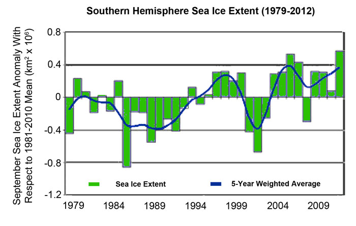
Southern hemisphere sea ice extent anomaly (km2 x 106) for each September from 1979 through 2012, along with the five-year weighted average. Anomalies were calculated with respect to the 1981-2010 climatology. From Reid et al. (2013).
Based on the results presented in the figure above, the five researchers calculate that sea ice extent in the Southern Hemisphere has experienced a mean positive trend of about 0.9 percent per decade, which is pretty amazing for a world described by climate alarmists as having experienced an unprecedented CO2-induced global warming ever since the dawn of industrialization and the mining and burning of coal, gas and oil, which they claim should be causing just the opposite to occur, i.e., a great reduction in polar sea ice extent.
In light of these seemingly inconsistent facts, therefore, the only thing we can conclude at this point in time is that for some still-unproven reason, and despite the supposedly unprecedented increases in mean global air temperature and atmospheric CO2 concentration that the planet has experienced since the late 1970s, Antarctic sea ice extent has stubbornly refused to do what climate models say it should be doing, as it just keeps on growing.
References
Cavalieri, D.J. and Parkinson, C.L. 2008. Antarctic sea ice variability and trends, 1979-2006. Journal of Geophysical Research 113: 10.1029/2007JC004564.
Cavalieri, D.J., Parkinson, C.L. and Vinnikov, K.Y. 2003. 30-Year satellite record reveals contrasting Arctic and Antarctic decadal sea ice variability. Geophysical Research Letters 30: 10.1029/2003GL018031.
Comiso, J.C. 2000. Variability and trends in Antarctic surface temperatures from in situ and satellite infrared measurements. Journal of Climate 13: 1674-1696.
Comiso, J.C. 2009. Variability and trends of the global sea ice cover. In: Thomas, D. and Dieckmann, G. (Eds.). Sea Ice, 2nd Edition. Wiley-Blackwell, pp. 205-246.
Comiso, J.C. and Nishio, F. 2008. Trends in the sea ice cover using enhanced and compatible AMSR-E, SSM/I, and SMMR data. Journal of Geophysical Research 113: 10.1029/2007JC004257.
Elderfield, H. and Rickaby, R.E.M. 2000. Oceanic Cd/P ratio and nutrient utilization in the glacial Southern Ocean. Nature 405: 305-310.
Fraser, A.D., Massom, R.A., Michael, K.J., Galton-Fenzi, B.K. and Lieser, J.L. 2012. East Antarctic landfast sea ice distribution and variability, 2000-08. Journal of Climate 25: 1137-1156.
Geibert, W., Assmy, P., Bakker, D.C.E., Hanfland, C., Hoppema, M., Pichevin, L.E., Schroder, M., Schwarz, J.N., Stimac, I., Usbeck, R. and Webb, A. 2010. High productivity in an ice melting hot spot at the eastern boundary of the Weddell Gyre. Global Biogeochemical Cycles 24: 10.1029/2009GB003657.
Hanna, E. 2001. Anomalous peak in Antarctic sea-ice area, winter 1998, coincident with ENSO. Geophysical Research Letters 28: 1595-1598.
Heil, P. 2006. Atmospheric conditions and fast ice at Davis, East Antarctica: A case study. Journal of Geophysical Research 111: 10.1029/2005JC002904.
Laine, V. 2008. Antarctic ice sheet and sea ice regional albedo and temperature change, 1981-2000, from AVHRR Polar Pathfinder data. Remote Sensing of Environment 112: 646-667.
Lannuzel, D., Schoemann, V., de Jong, J., Tison, J.L. and Chou, L. 2007. Distribution and biogeochemical behavior of iron in the East Antarctic sea ice. Marine Chemistry 106: 18-32.
Mahoney, A., Eicken, H., Gaylord, A.G. and Shapiro, L. 2007. Alaska landfast sea ice: Links with bathymetry and atmospheric circulation. Journal of Geophysical Research 112: 10.1029/2006JC003559.
Murphy, E.J., Clarke, A., Symon, C. and Priddle, J.J. 1995. Temporal variation in Antarctic sea-ice: Analysis of a long term fast-ice record from the South Orkney Islands. Deep-Sea Research I 42: 1045-1062.
Parkinson, C.L. 2002. Trends in the length of the Southern Ocean sea-ice season, 1979-99. Annals of Glaciology 34: 435-440.
Parkinson, C.L. 2004. Southern Ocean sea ice and its wider linkages: insights revealed from models and observations. Antarctic Science 16: 387-400.
Pezza, A.B., Rashid, H.A. and Simmonds, I. 2012. Climate links and recent extremes in Antarctic sea ice, high-latitude cyclones, Southern Annular Mode and ENSO. Climate Dynamics 38: 57-73.
Reid, P.A., Tully, M.B., Klekociuk, A.R., Krummel, P.B. and Rhodes, S.K. 2013. Seasonal climate summary Southern Hemisphere (spring 2012): Warmer and drier across much of Australia, along with a new Southern Hemisphere sea ice extent record. Australian Meteorological and Oceanographic Journal 63: 427-442.
Tedesco, M. and Monaghan, A.J. 2010. Climate and melting variability in Antarctica. EOS, Transactions, American Geophysical Union 91: 1-2.
Turner, J., Comiso, J.C., Marshall, G.J., Lachlan-Cope, T.A., Bracegirdle, T., Maksym, T., Meredith, M.P., Wang, Z. and Orr, A. 2009. Non-annular atmospheric circulation change induced by stratospheric ozone depletion and its role in the recent increase of Antarctic sea ice extent. Geophysical Research Letters 36: 10.1029/2009GL037524.
Turner, J., Overland, J.E. and Walsh, J.E. 2007. An Arctic and Antarctic perspective on recent climate change. International Journal of Climatology 27: 277-293.
Vyas, N.K., Dash, M.K., Bhandari, S.M., Khare, N., Mitra, A. and Pandey, P.C. 2003. On the secular trends in sea ice extent over the Antarctic region based on OCEANSAT-1 MSMR observations. International Journal of Remote Sensing 24: 2277-2287.
Watkins, A.B. and Simmonds, I. 2000. Current trends in Antarctic sea ice: The 1990s impact on a short climatology. Journal of Climate 13: 4441-4451.
Yuan, X. and Martinson, D.G. 2000. Antarctic sea ice extent variability and its global connectivity. Journal of Climate 13: 1697-1717.
Zwally, H.J., Comiso, J.C., Parkinson, C.L. Cavalieri, D.J. and Gloersen, P. 2002. Variability of Antarctic sea ice 1979-1998. Journal of Geophysical Research 107: 10.1029/2000JC000733.
Last updated 22 July 2015