


| Tweet | Follow @co2science |
Paper Reviewed
Reid, P.A., Tully, M.B., Klekociuk, A.R., Krummel, P.B. and Rhodes, S.K. 2013. Seasonal climate summary Southern Hemisphere (spring 2012): Warmer and drier across much of Australia, along with a new Southern Hemisphere sea ice extent record. Australian Meteorological and Oceanographic Journal 63: 427-442.
Down under in Australia - based on analyses prepared by the staff of that country's Bureau of Meteorology's National Climate Centre and its Centre for Australian Weather and Climate Research - the team of Reid et al. (2013) assessed the history of Southern Hemisphere sea ice extent over the period of available satellite observations (1979-2012), a graph of which results for each September of that record is portrayed in the figure below.
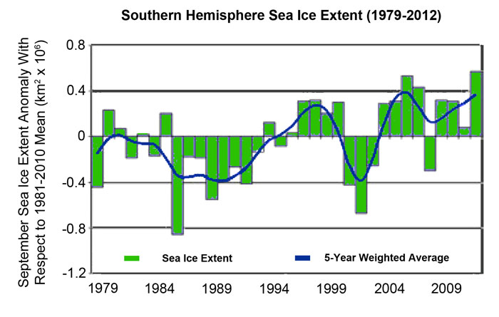
Southern hemisphere sea ice extent anomaly (km2 x 106) for each September from 1979 through 2012, along with the five-year weighted average. Anomalies were calculated with respect to the 1981-2010 climatology. From Reid et al. (2013).
Based on the results presented in the figure above, the five researchers calculate that sea ice extent in the Southern Hemisphere has experienced a mean positive trend of about 0.9 percent per decade, which one must admit is not too bad, especially for a world described by climate alarmists as having experienced an unprecedented CO2-induced global warming ever since the dawn of industrialization and the mining and burning of coal, gas and oil, which many of them claim should be doing just the opposite, i.e., producing a great reduction in polar sea ice extent.
Posted 19 February 2015