Reference
Carson, E.C., Knox, J.C. and Mickelson, D.M. 2007. Response of bankfull flood magnitudes to Holocene climate change, Uinta Mountains, northeastern Utah. Geological Society of America Bulletin 119: 1066-1078.
Description
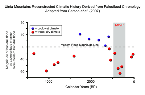
Carson et al. developed a Holocene history of flood magnitudes in the northern Uinta Mountains of northeastern Utah (40°48'-40°58'N, 110°18'-110°48'W) from reconstructed cross-sectional areas of alluvial channels preserved within floodplain sediments and relationships relating channel cross-sections to flood magnitudes derived from modern stream gage and channel records. This work revealed that over the past 5,000 years, the record of flood discharges "corresponds well with independent paleoclimate data for the Uinta Mountains," and that "during this period, the magnitude of the modal flood is smaller than modern during warm dry intervals and greater than modern during cool wet intervals." In addition, the researchers found that "the decrease in flood magnitudes following 1000 cal yr B.P. corresponds to numerous local and regional records of warming during the Medieval Climatic Anomaly." The three largest such negative departures from modern flood magnitudes (indicating greater than modern warmth) occur between AD 1250 and 1400, as determined from radiocarbon dating of basal channel-fill sediments; and they range from -15 to -22%.