


| Tweet | Follow @co2science |
Paper Reviewed
Zhang, R., Zhang, T., Kelgenbayev, N., He, Q., Maisupova, B., Mambetov, B.T., Chen, F., Dosmanbetov, D., Shang, H., Yu, S. and Yuan, Y. 2017. A 189-year tree-ring record of drought for the Dzungarian Alatau, arid Central Asia. Journal of Asian Earth Sciences 148: 305-314.
The arid Central Asia (ASA) region encompasses an area that houses 55 million people from six countries. Despite this large population, few long-term climate records exist in the ASA from which scientists and policy makers can discern the full range of natural hydroclimate variability, which is needed to help insulate citizens from the devastating impacts of drought and floods.
Hoping to fill this data void, the eleven-member research team of Zhang et al. (2017) set out to reconstruct a long-term record of historic drought for the Dzungarian Alatau, a region located in the northern Tianshan Mountains of the ACA. In accomplishing this objective, they obtained 46 tree ring samples from 24 Schrenk spruce (Picea schrenkiana), the width chronologies of which were utilized as proxies for historical drought (specifically, the Palmer Drought Severity Index, PSDI) over the 189-year period 1828-2016, as shown in the figure below.
As indicated in Figure 1, there are several high-frequency alterations in the historic drought record, where the drought index can vary by more than one standard deviation from year to year. Extreme drought years (more than 2 standard deviations below the mean) occurred in 1917, 1927 and 1945. Conversely, extremely moist years (more than 2 standard deviations above the mean) occurred in 1897, 1967, 1973, 1993 and 1994. Power spectral analysis further revealed multiple cycles in the historic drought record, which the authors attributed to possible forcings related to (1) the Quasi Biennial Oscillation in the stratosphere or to the Tropospheric Biennial Oscillation that affected westerly windflow (a 2.1- and 2.9-year cycle), (2) ENSO (a 4.1- and 5.5-year cycle), and (3) the Schwabe cycle of solar activity (a 9.5- and 10.8-year cycle). Additional information obtained from the data via wavelet power spectrum revealed "large power in the 30-40 year cycles," leading the authors to suggest that "the PSDI of the Dzungarian Alatau may be associated with solar activity."
All in all, the above findings are important in what they reveal about drought in the ASA. There is little indication it has increased in frequency and/or intensity over the past two centuries and its fluctuation appears to be driven by natural and not anthropogenic (human-caused global warming) forcings.
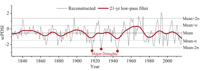
Figure 1. Reconstructed drought (scPDSI) for the Dzungarian Alatau region since 1828 (thin line). The thick red line shows the data smoothed with a 21-year low-pass filter to emphasize the long-term fluctuations. The solid horizontal line represents the long-term mean for the period 1828-2016; the dashed horizontal lines represent the mean value ± 1σ while the dotted horizontal lines represent the mean value ± 2σ. The red dots represent extreme drought years. Source: Zhang et al. (2017).