


| Tweet | Follow @co2science |
Paper Reviewed
DeRose, R.J., Bekker, M.F., Wang, S.-Y., Buckley, B.M., Kjelgren, R.K., Bardsley, T., Rittenour, T.M. and Allen, E.B. 2015. A millennium-length reconstruction of Bear River stream flow, Utah. Journal of Hydrology 529: 524-534.
One of the claims of climate alarmism that rears its ugly head from time to time is that CO2-induced global warming is adversely impacting Earth's water resources by inducing large changes in global streamflow characteristics. A good test of this hypothesis is to examine long-term proxy streamflow records to see how they may or may not have changed over the past century, during which time climate alarmists claim temperatures and atmospheric CO2 concentrations rose to levels unprecedented over thousands and hundreds of thousands of years, respectively. Thanks to the work of DeRose et al. (2015), this hypothesis can now be tested for the Bear River watershed in the eastern Great Basin of Utah, Wyoming and Idaho.
Working with tree core specimens from multiple living and dead Utah juniper trees, the eight-member research team derived what they describe as a "robust climate reconstruction" and "an excellent proxy for stream flow in northern Utah" over the period 800-2010 AD. And what did that record reveal?
As shown in the figure below, multiple wet and dry periods occurred throughout the 1200-year reconstruction, of which spectral analysis revealed significant periodicities at decadal, multi-decadal and centennial time scales. The most severe period of reduced streamflow occurred during between 1210 and 1281. Centered on the Medieval Warm Period, this 71-year long drought was nearly twice the magnitude of the second largest drought, which lasted 38 years and ended in in 1462. On the other end of the hydrologic spectrum, the most extreme wet period lasted 46 years (from 1378 to 1424), while a similar wet period, ranking as the second largest pluvial event, lasted 39 years and ended in the year 2000.
The significance of DeRose et al.'s work is noted in the fact that both drier and wetter conditions have prevailed in the eastern Great Basin as a feature of natural climate change than what has occurred during the instrumental era of the past century. And although there appears to be no evidence of a CO2-induced influence on these data, it is important for public and private water users of this region to recognize the periodic large-scale wet and dry periods that oscillate naturally in this basin, so that they can more effectively plan and prepare for such events that presently remain "hitherto unknown" in the instrumental record.
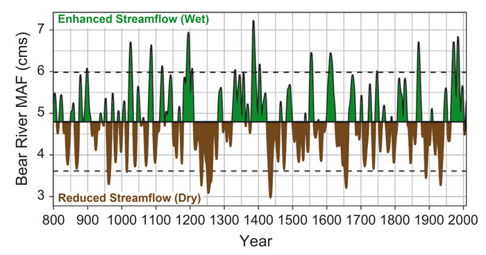
Figure 1. Reconstructed Bear River decadal-scale drought (brown) and wet (green) periods from cubic smoothing spline with frequency response of 25% at wavelength 10 years. Dashed lines indicate 1 SD from reconstruction mean. Adapted from DeRose et al. (2016).