


| Follow @co2science |
Paper Reviewed
Brook, G.A., Railsback, L.B., Scott, L., Voarintsoa, N.Y.G. and Liang, F. 2015. Late Holocene Stalagmite and Tufa Climate Records for Wonderwerk Cave: Relationships between Archaeology and Climate in Southern Africa. African Archaeological Review 32: 669-700.
Introducing their study, Brook et al. (2015) write that "horizontal cores from a large stalagmite and two tufa deposits in the entrance to Wonderwerk Cave, South Africa, dated by radiocarbon methods, have provided climate proxy data on late Holocene environments near the cave," further noting that the δ18O and δ13C time series from the stalagmite and tufa cores "correlate well with isotope records for other sites in the summer rainfall zone of southern Africa and suggest that late Holocene warm periods in the Northern Hemisphere, including the Medieval Warm Period, Roman Warm Period and Minoan Warm Period, were times of increased moisture in this rainfall zone," while intervening cold periods were times of reduced rainfall.
So which of the climate intervals that were studied in most detail were the most conducive to successful habitation by South Africans: the warm and wet periods or the cold and dry periods?
As shown in the figure below, the five researchers report that "comparison of the Wonderwerk records with information on human settlement patterns, agricultural expansion or decline, and population growth or decline, shows that growth occurred preferentially during wetter climate periods," which were also the warmer climate periods. The cold and dry periods, on the other hand, were so difficult for the indigenous people to deal with that they ultimately led to "abandonment of the important town of Mupungubwe in the Shashe-Limpopo area of northeast South Africa," as well as "the fall of Great Zimbabwe."
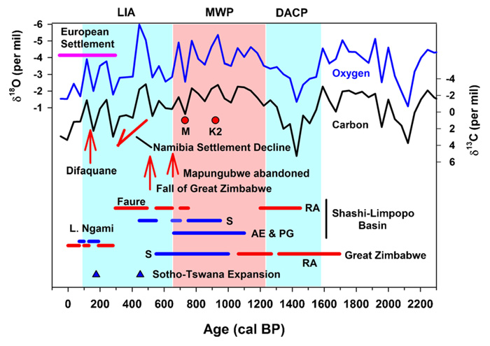
The Wonderwerk isotope record compared with human settlement and environmental conditions at sites in southern Africa (image in full color online). L. Ngami (Botswana) = high lake levels in blue, very dry conditions in red, RA = rainmaking activities (red), S = settlement activities such as houses and grain storage bins (blue), AE & PG = agricultural expansion and population growth,M= shift of center from K2 toMapungubwe, K2 = shift of center from Schroda to K2, Faure = evidence of dry conditions in this settlement. Source: Brook et al. (2015).